Broad use of OpenTopography across educational institutions
As part of OpenTopography’s mission to democratize access to high resolution topography and advance our understanding of Earth’s surface, vegetation, and the built environment, we are dedicated to developing and supporting educational uses of topographic data. To evaluate OpenTopography’s educational impact, we assessed the diversity and breadth of educational institutions that use OpenTopography. OpenTopography’s educational resources, datasets, and processing tools are used by students and faculty at a wide variety of educational institutions, illustrating the broad impact of OpenTopography’s resources across many stages of education.
OpenTopography offers a suite of ready-to-use educational resources to facilitate the integration of high resolution topography into classroom lessons and activities at a variety of levels. In addition to using these resources, users from educational institutions can directly access data from OpenTopography for use both in the classroom and for scientific research in research publications. With easy-to-use on-demand processing tools, OpenTopography helps lower the barrier to entry for working with topographic data.
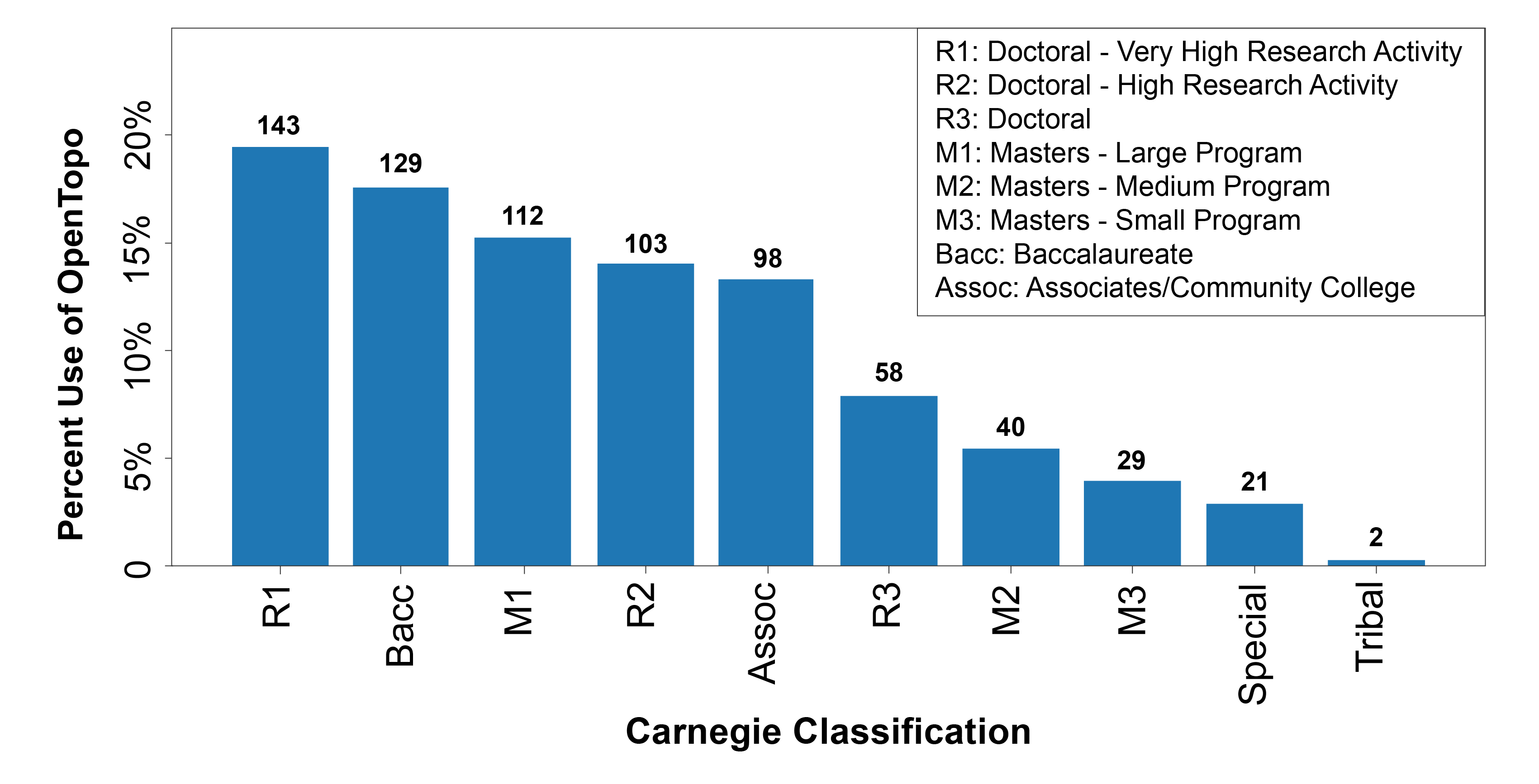
To measure the impact of OpenTopography’s educational resources, we tallied the number of educational institutions (not individual users) that have accessed data via OpenTopography and sorted these institutions based on their Carnegie Classification. The Carnegie Classification is a framework used to recognize and describe different types of institutions in U.S. higher education. The figure below shows the percentage use and count of educational institutions sorted by Carnegie Classification.

Higher education institutions with members who have accessed data via OpenTopography sorted by Carnegie Classification. Institution counts are at the bar top.
This analysis shows tens of thousands of individuals from across 735 different higher education institutions have accessed data from OpenTopography. The three most common institutional classes of OpenTopography users come from very high research activity doctoral institutions (R1), baccalaureate institutions (Bacc), and masters institutions (M1). Nearly 100 different associates and community colleges use OpenTopography to access topographic data.
Through OpenTopography’s cutting edge cyberinfrastructure, users across the full spectrum of institutions have direct access to high performance compute resources—resources that traditionally may not be available to non-R1 institutions. OpenTopography helps bring the power of supercomputers directly to the user, regardless of home institution resources, thereby enabling wide-ranging educational and research applications of topographic data.
Given that hundreds of institutions where OpenTopography users come from are non-doctorate granting institutions, we see that OpenTopography and topographic data are used across a broad educational user base. The diversity of institutions demonstrates the use of OpenTopography’s resources throughout the full spectrum of academic and workforce preparation.
Pete Lippert, an Associate Professor at the University of Utah, provides an example of how OpenTopography and high resolution topography are used in introductory-level undergraduate classrooms:
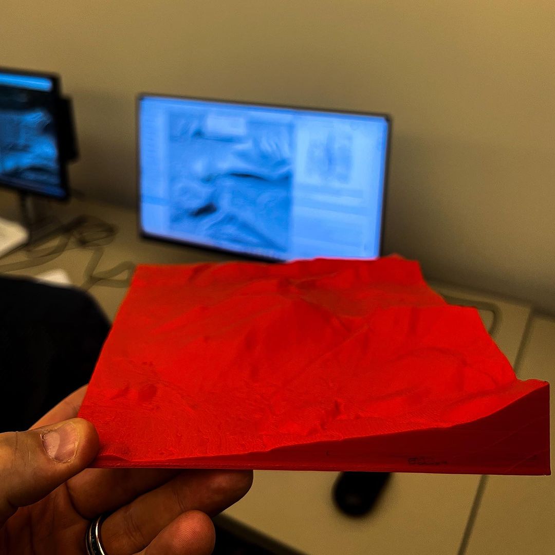
Geoscience students at the University of Utah discover the unique benefits of high resolution topography and accessible data early and often in their undergraduate education. Wasatch in the Field is a place-based, introductory field course that surveys the breadth of geoscience taught at Utah. The course assumes no prior experience with geoscience or field work and guides students to read the rocks, soil, landscape, and water to understand the history of glaciers, earthquakes, and landslides, as well as water quality and use, along the Wasatch Front. High resolution topography collected via lidar and available on OpenTopography are the backbone of several field and lab-based mapping exercises. Students learn to access data on the website, produce various data products, and use those products to address specific questions related to geologic hazards. Students also see how these topographic datasets are transformed into the 3D printed landscape models to provide another view of geological features and processes. Later in their curriculum, Geoscience students use digital terrain models produced by OpenTopography online tools to investigate tectonic geomorphology (Structural Geology, Geomorphology), landslides (Geological Engineering, Field Methods, Field Camp), and more.

3D printed model of Bell’s Canyon near Salt Lake City, Utah from high resolution topography that students at the University of Utah used to help map moraines and faults. Photo by Pete Lippert.
Are you an educator that uses OpenTopography data or resources in the classroom, or have questions about how to use OpenTopography in the classroom? Please reach out to info@opentopography.org if you are interested in sharing your educational use of high resolution topography.
