Highlight: February-May 2023 publications using OpenTopography datasets
by Emily Zawacki and Chelsea Scott
OpenTopography periodically highlights new research results that demonstrate the use and reuse of data from OpenTopography. These four publications highlight topographic research applications in geomorphology, earthquakes, coastal processes, and ecology and conservation.
Controls and thresholds on steep mountain streams
Small streams at the top of mountains are often steep and prone to generating debris flows—fast-moving masses of unconsolidated rocky material. These steep streams play an important role in storing and transporting sediment from hillslopes to downstream rivers. To better understand how steep mountain landscapes evolve, Neely and DiBiase evaluated the transition between debris flow-prone channels and downstream channels dominated by water-based sediment transport across the western United States. Based on lidar-derived topography, erosion rates, and sediment sizes, the authors studied the variations in channel shape and calculated the stream flow and debris flow activity needed to transport and erode sediment. They found significant variation in channel relief, with higher relief channels having longer portions shaped by debris flow activity and a coarser sediment cover. Their results indicate that the transition between debris flow-prone channels and channels with water-based transportation is a result of an erosional threshold dependent on the grain size, and whether sediment is moved through mass wasting or water transported.
- Data used:
- Southern California Bedrock Landscapes 2015 Airborne Lidar
- Eel River Critical Zone Observatory July 2014 Lidar Survey
- Oregon Department of Geology and Mineral Industries Lidar Program Data
- Northern California Coast: Slope Failure in Low and High Uplift Regions
- Quantifying rock strength controls in Guadalupe Mountains, NM/TX
- Steep Headwater-Colluvial Channels, Day Creek, San Gabriel Mountains CA, US (Community Dataspace)
- McKittrick Canyon Reef Trail strat section, Guadalupe Mtns Nat. Park, TX (Community Dataspace)
- Publication: Neely, A. B., & DiBiase, R. A. (2023). Sediment controls on the transition from debris flow to fluvial channels in steep mountain ranges. Earth Surface Processes and Landforms. https://doi.org/10.1002/esp.5553.
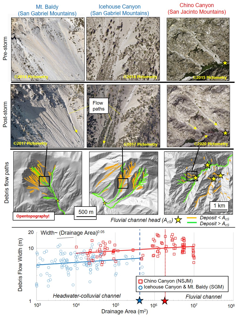
Imagery before and after storms that produced debris flows, with debris flow paths mapped on lidar topography. The combination of repeat high resolution imagery and lidar topography is used to measure empirical relationships between drainage area and debris flow width in the three sites (bottom plot). Image credit: Dr. Al Neely.
How pre-existing structures in the crust can control earthquake rupture
Faults often develop along pre-existing structures in the crust like dikes—vertical sheets of igneous rock intruded through pre-existing rock. These pre-existing structures can dictate where an earthquake occurs and how it propagates. Nevitt et al. explored how a long zone of dikes in California, known as the Independence dike swarm, may have influenced the development of faults where the 2019 magnitude 7.1 Ridgecrest earthquake occurred. These dikes can be identified both in satellite imagery and lidar-derived digital elevation models, and the authors mapped thousands of dikes near the Ridgecrest earthquake rupture. They found that the fault rupture largely followed the orientation of the dikes and proposed that these pre-existing crustal structures had a strong control on how the fault moved during the earthquake. Based on these results, other large nearby earthquakes—like the 1992 magnitude 7.3 Landers and the 1999 magnitude 7.1 Hector Mine earthquakes—should be re-evaluated to understand if the pre-existing structures also influenced the development of these fault zones.
- Data used:
- Publications: Nevitt, J. M., Brooks, B. A., Hardebeck, J. L., & Aagaard, B. T. (2023). 2019 M7. 1 Ridgecrest earthquake slip distribution controlled by fault geometry inherited from Independence dike swarm. Nature Communications, 14(1), 1546. https://doi.org/10.1038/s41467-023-36840-2
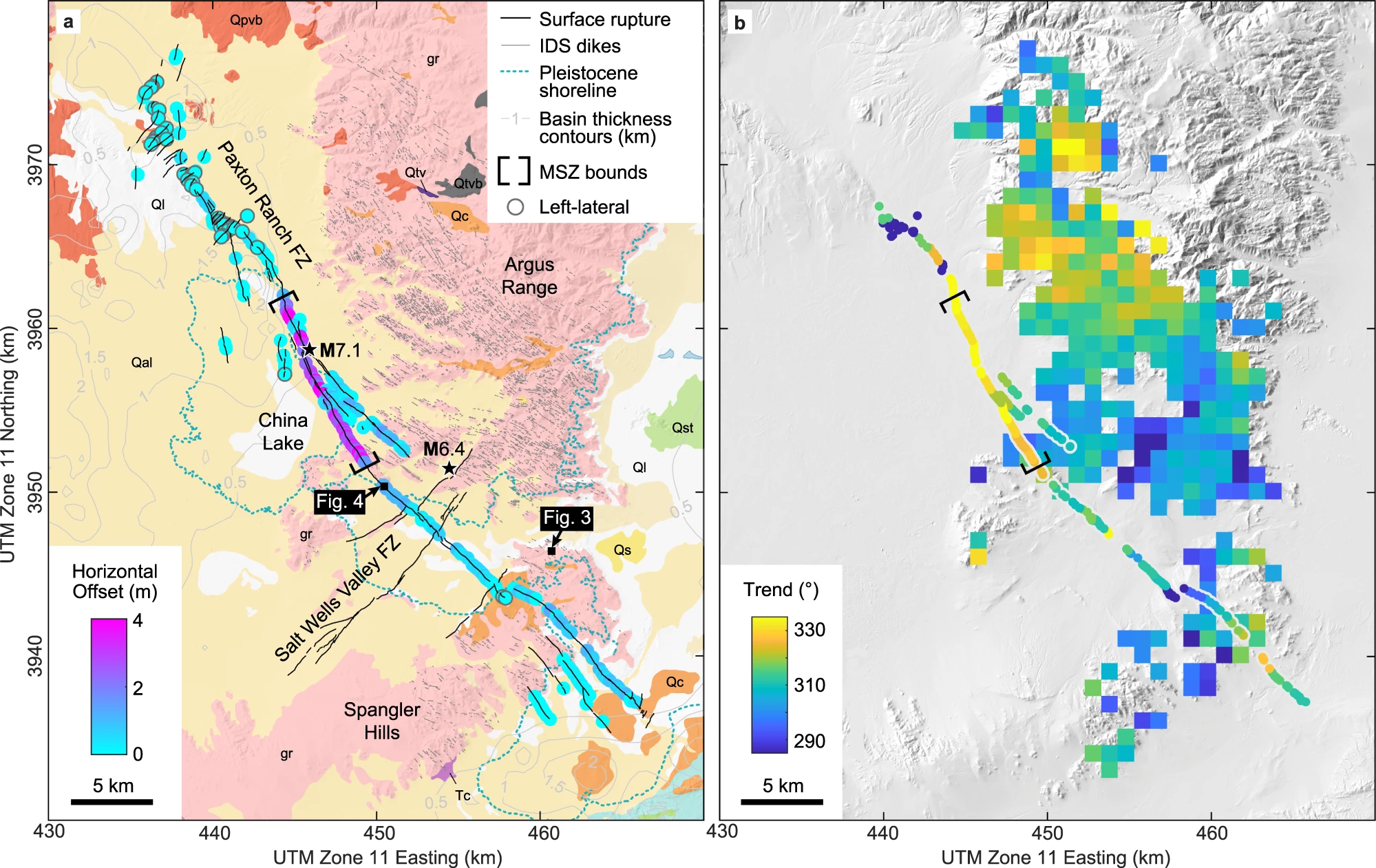
A comparison of the horizontal offset of the M7.1 Ridgecrest earthquake with geologic structures (left) and the trend (cardinal direction) of earthquake rupture and dikes (right). Figure from Nevitt et al. (2023).
Monitoring coastal erosion in Malta
Coasts along the Maltese archipelago in the Mediterranean Sea have been experiencing significant erosion from landslides, which threaten infrastructure and tourism-based economic activities. To understand the danger posed by these coastal landslides, Colica et al. undertook a multidisciplinary study along the north coast of Malta using geospatial and geophysical techniques. They used geophysical tools to map subsurface variations in rock type, joints, and fractures. The authors performed an uncrewed aerial vehicle (UAV) or drone survey around the cliffs to create a digital elevation model using Structure from Motion (SfM) photogrammetry. In comparing the UAV-derived imagery to aerial photographs dating back to 1957, the authors were able to track cliff blocks that had collapsed over time. The combined results help to monitor the evolution of the coastline and better understand how erosive processes affect unstable cliffs.
The data used in this study were submitted to the OpenTopography Community Dataspace for publication.
- Publication: Colica, E., Galone, L., D’Amico, S., Gauci, A., Iannucci, R., Martino, S., Pistillo, D., Iregbeyen, P., & Valentino, G. (2023). Evaluating Characteristics of an Active Coastal Spreading Area Combining Geophysical Data with Satellite, Aerial, and Unmanned Aerial Vehicles Images. Remote Sensing, 15(5), 1465. https://doi.org/10.3390/rs15051465
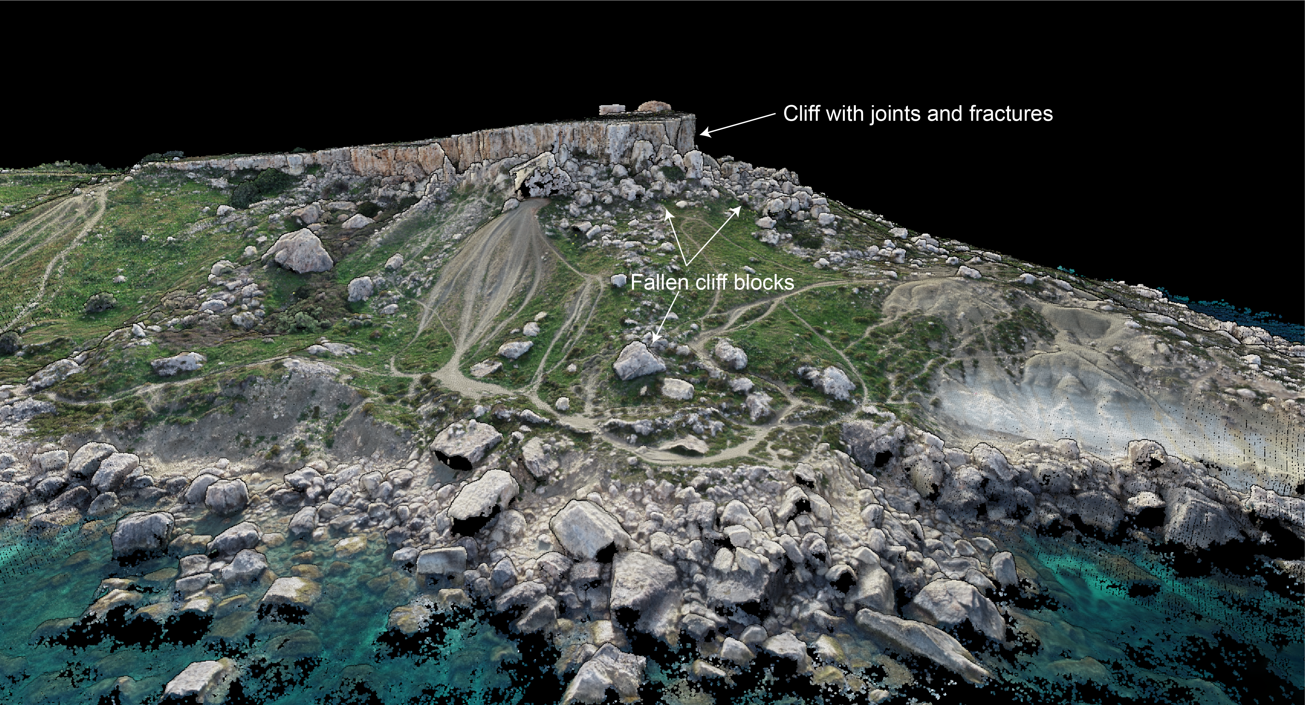
3D point cloud colorized by RBG values of the Selmun promontory on the northern coast of Malta highlighting fallen cliff blocks from landsliding.
Exploring habitat suitability of wild Asian elephants
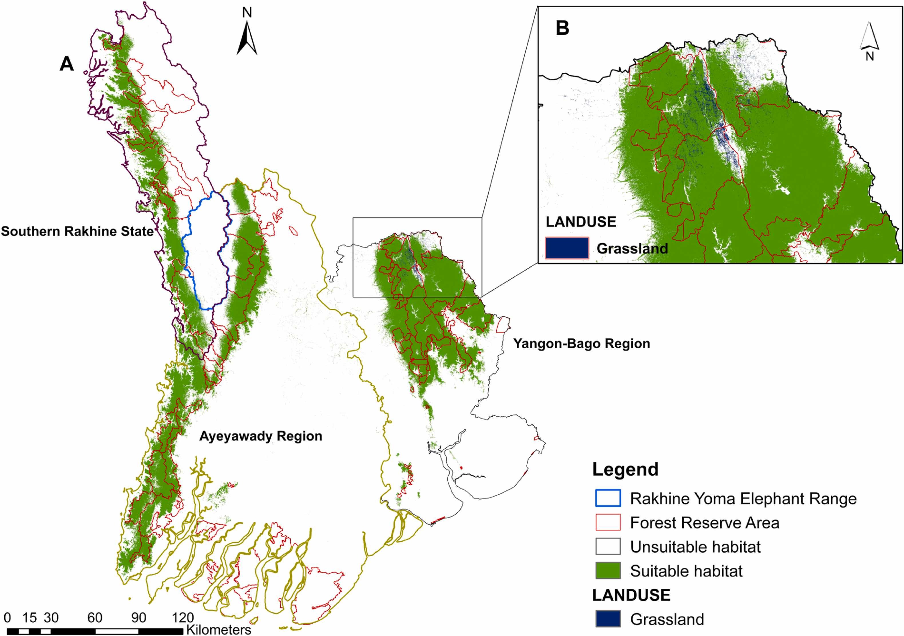
Habitat destruction and poaching threaten the distribution and population of wild Asian elephants. Habitat loss increases the number of incidents of conflict between people and elephants, often harming human lives and property and threatening elephant conservation. To better understand the association between wild Asian elephant habitat and human-elephant conflicts, Thant et al. identified the habitats that were used by wild Asian elephants in Myanmar. They tracked the movement of 25 elephants with GPS collars in southwestern Myanmar and evaluated their locations compared to different environmental variables including topography (e.g., elevation and the ruggedness of the terrain), climate, vegetation, and human footprint. They found that elephants preferred to live at lower elevations, with nearby water sources and adequate precipitation. Elephants highly used grasslands and degraded forests, which are not an optimal habitat due to their disturbance from and proximity to humans. The study concluded that human encroachment has intensified human-elephant conflict and that these areas should be monitored and forests restored to reduce conflict.
- Publication: Thant, Z. M., Leimgruber, P., Williams, A. C., Oo, Z. M., Røskaft, E., & May, R. (2023). Factors influencing the habitat suitability of wild Asian elephants and their implications for human–elephant conflict in Myanmar. Global Ecology and Conservation, 43, e02468. https://doi.org/10.1016/j.gecco.2023.e02468
 |
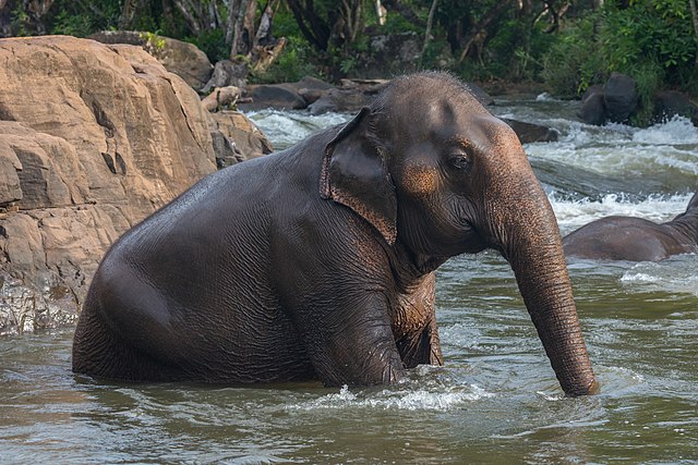 |
(Left) Map of habitat suitability of wild Asian elephants in southwest Myanmar. From Thant et al. (2023). (Right) An Asian elephant (Photo: Basile Morin)
OpenTopography is supported by the U.S. National Science Foundation and facilitates access to topographic data for Earth and other scientific research and education. We closely track peer-reviewed publications that use OpenTopography data and services as they are an important measure of our impact.
Have a new paper out that uses data or services provided by OpenTopography and want us to highlight it in a future blog post? Drop us a note: info@opentopography.org
