New Machine Learning Derived Digital Terrain Models
Jul 2, 2026
OpenTopography is pleased to announce the availability of two new continental to global-scale digital terrain models (DTMs): ANADEM, covering South America, and the Global Ensemble Digital Terrain Model (GEDTM), covering nearly all global landmasses. Both datasets represent a significant advance in the ability to characterize bare-earth terrain from existing Digital Surface Models.
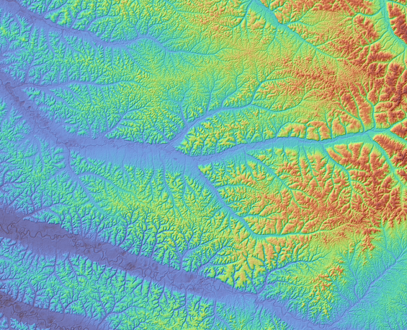
A Digital Terrain Model (DTM) of a section of the Congo River basin. The DTM is colored by elevation and draped on a hillshade generated from the Global Ensemble Digital Terrain Model (GEDTM).
Why Bare-Earth Terrain Is So Difficult to Map
Most freely available global elevation datasets - including the widely used Copernicus GLO-30 - are actually Digital Surface Models (DSMs). A DSM captures the elevation of whatever is on top of the ground: buildings, vegetation, and tree canopy. In open terrain this distinction barely matters, but in densely forested regions like the Congo or the Amazon, the difference between the DSM and the true ground surface can be quite large.
A Digital Terrain Model (DTM), by contrast, represents the bare-earth surface beneath the vegetation. DTMs are essential for applications like flood modeling, watershed delineation, archaeology, and carbon stock estimation - all of which depend on knowing the location of the actual ground surface.
Traditional approaches to DTM generation rely on airborne lidar, which can filter out vegetation returns to reveal the ground below. Over vast tropical forests, however, airborne surveys are prohibitively expensive, logistically challenging, and for much of the world, simply haven't been done. Space-based lidar instruments offer a broader alternative, and some are capable of measuring ground elevation beneath forest canopy from orbit. However, satellite orbital geometry imposes a fundamental constraint: these systems generally collect data along discrete, widely-spaced ground tracks rather than continuous, overlapping swaths, making truly gap-free global coverage difficult to achieve from spaceborne lidar alone.
A Machine Learning Solution Using Space-Based Lidar
Both ANADEM and GEDTM take a similar approach to solving this problem: each applies machine learning techniques on space-based lidar measurements of bare-earth elevation to correct an existing DSM, teaching the model how to "see through" forest canopy and other above-ground structures. Both rely, at least in part, on ground elevation measurements from NASA's Global Ecosystem Dynamics Investigation (GEDI) lidar instrument aboard the International Space Station and ICESat-2, a NASA laser altimetry satellite, which together provide billions of canopy-penetrating ground elevation points worldwide.
GEDTM fuses several global elevation sources, including the Copernicus GLO-30 DSM, ALOS World 3D, and object height models, then uses a two-stage random forest model trained on nearly 30 billion GEDI and ICESat-2 ground points to produce a globally consistent bare-earth terrain model.
ANADEM takes a regionally tuned approach. It starts from the Copernicus GLO-30 DSM alone and removes vegetation bias using a TreeBoost model trained on GEDI returns together with Landsat-8 and Sentinel-2 spectral indices (EVI, NDMI, MSAVI), calibrated specifically for South America's tropical and subtropical vegetation. ICESat-2 data is used to validate ANADEM's results rather than train the model directly.
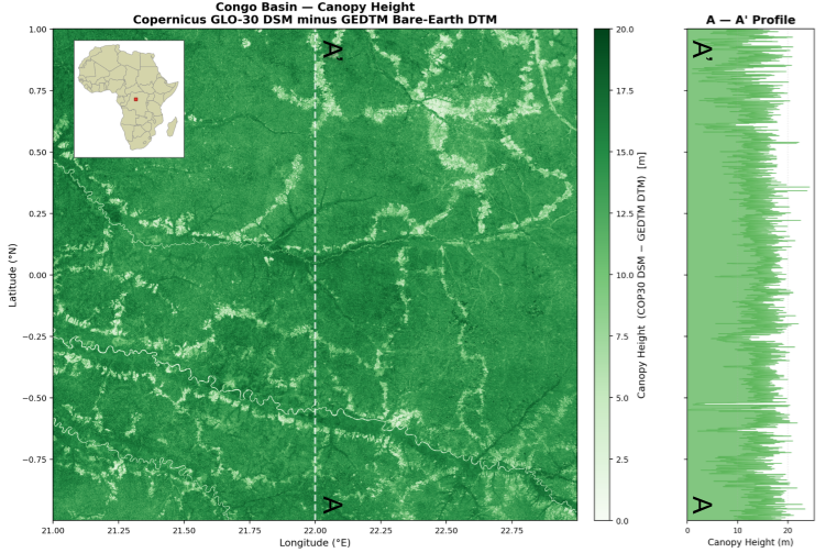
A Canopy Height Model (CHM) over the Congo derived by differencing the GEDTM DTM from the Copernicus DSM. Profile on the right panel shows the canopy height along the 22 degree East longitude line (dashed A to A' line). Tree heights average roughly 13.5 meters and often exceed 20 meters in height in this area.
ANADEM: A DTM for South America
ANADEM provides bare-earth terrain coverage across the full South American continent at 30-meter resolution. The dataset is particularly impactful in the Amazon basin, where dense, closed-canopy rainforest has historically made accurate terrain mapping nearly impossible. The dataset is described in detail in the paper:
Laipelt, L.; Comini de Andrade, B.; Collischonn, W.; de Amorim Teixeira, A.; Paiva, R.C.D.d.; Ruhoff, A. ANADEM: A Digital Terrain Model for South America. Remote Sens. 2024, 16, 2321. https://doi.org/10.3390/rs16132321
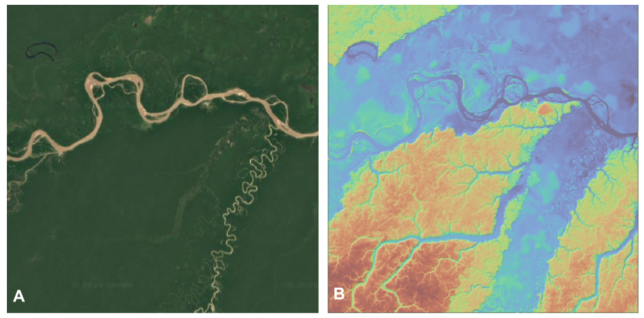
Image A shows the Google Earth imagery over the upper reaches of the Amazon River in Brazil. Panel B is the DTM generated using ANADEM over the same region, revealing the topography under the dense amazon rain forest.
GEDTM: A Global Bare-Earth DTM
GEDTM extends these techniques to the entire globe, delivering a consistent 30-meter DTM for all land masses. This makes it the broadest-coverage ML-derived terrain product currently available, filling critical gaps in regions like Central Africa, Southeast Asia, and the boreal forests of the northern latitudes. The dataset and methodology are described in the paper:
Ho Y, Grohmann CH, Lindsay J, Reuter HI, Parente L, Witjes M, Hengl T. 2025. GEDTM30: global ensemble digital terrain model at 30 m and derived multiscale terrain variables. PeerJ 13:e19673. https://doi.org/10.7717/peerj.19673
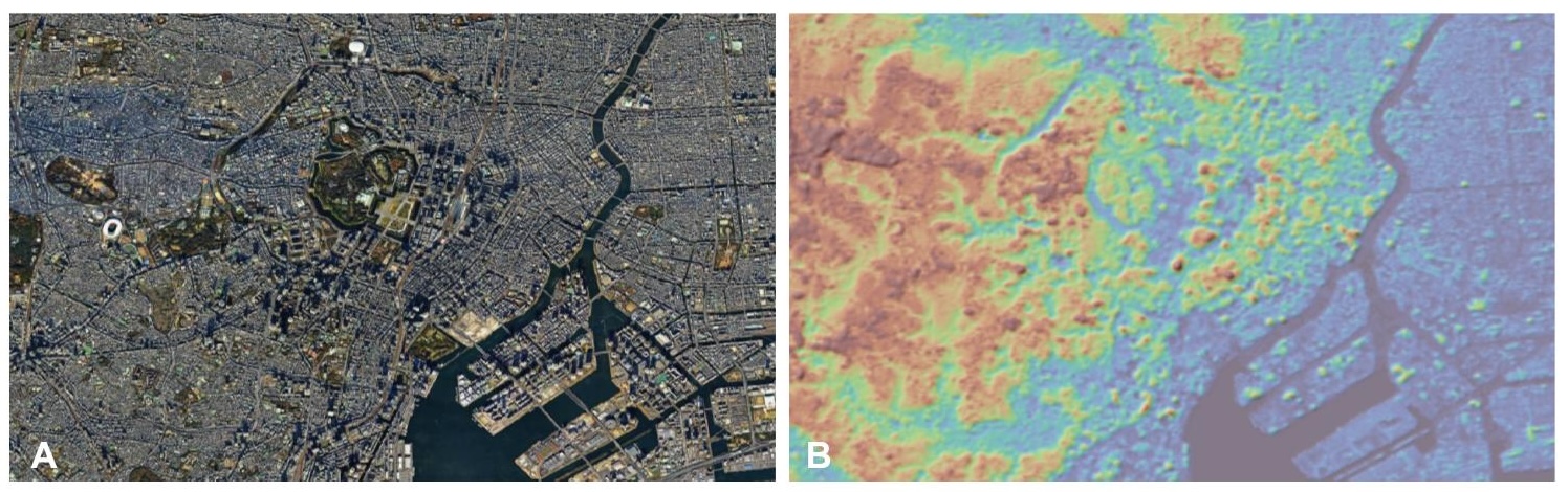
Image A shows the Google Earth imagery over Tokyo. Panel B is the DTM generated using GEDTM over the same region, revealing the Tokyo's topography with the buildings removed.
Accessing These Datasets
Both ANADEM and GEDTM are freely available through OpenTopography's global raster data portal. Users can define an area of interest and download or visualize the data directly in the browser. Both datasets can also be accessed programmatically via OpenTopography's global DEM API, as well as the point elevation API.
Data Access:
- Access ANADEM on OpenTopography: https://doi.org/10.5069/G9736P4G
- Access GEDTM on OpenTopography: https://doi.org/10.5069/G9BV7DT1
Whether you're modeling floodplains in the Amazon, mapping forest carbon in the Congo, or studying the base terrain below major cities, these new DTMs offer a powerful new resource for research and applications that depend on knowing the actual ground location.