October 2025 Data Releases
Nov 3, 2025
OpenTopography provides easy, centralized access to a diverse collection of topographic data. We strive to simplify data discovery by providing a single, accessible platform that integrates data from a variety of sources including the USGS 3D Elevation Program (3DEP), NOAA Coastal Lidar, Natural Resources Canada, Polar Geospatial Center, and many more. Below are highlights of datasets that became available or were updated on the OpenTopography platform in October 2025.
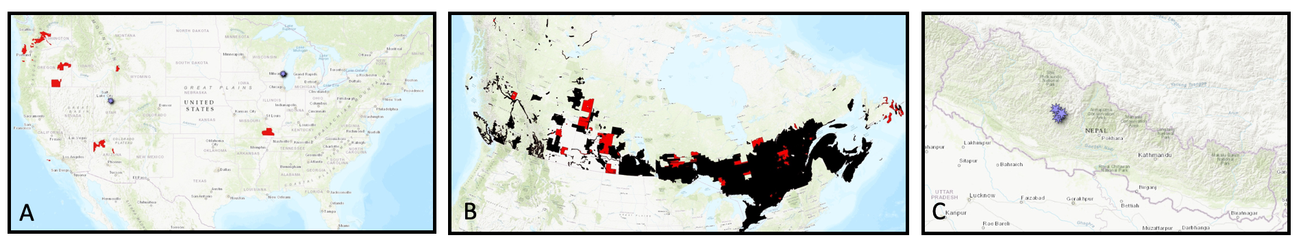
A. Location of new USGS 3DEP in red, and new Community Data Space in purple. B. Location of existing 1 meter DEMs over Canada in black, with new October 2025 additions in red. C. Location of new Community Dataspace datasets in Nepal in purple.
USGS 3D Elevation Program (3DEP) Datasets
The USGS is currently making 3DEP lidar point cloud data available via an Amazon Web Services (AWS) S3 Requester Pays Bucket, and as an AWS Public Dataset. To learn more about 3DEP and AWS see this USGS press release: USGS 3DEP Lidar Point Cloud Now Available as Amazon Public Dataset. Consistent with OpenTopography's mission of making high resolution topography data easier to discover and use, we provide a layer of value-added services that enable our users to subset, grid, download, and/or visualize any portion of the USGS 3DEP collection.
USGS 3DEP data is freely available to our core US academic user community (e.g. users who register with a .edu email domain). However, non-academics can access 3DEP data, as well as all other restricted datasets, by signing up for OpenTopography Plus (OT+). OT+ is a subscription service that enables one-stop, easy-to-use access to the highest quality lidar topography for the US. For more details about OT+, or to sign up, see the OT+ signup page.
New USGS 3DEP Datasets:
- WY GrandTetonNP 1 D22
- OR WWildfires 2 A22
- OR SouthEast 8 D22
- OR Malheur 1 A22
- OR SouthEast 6 D22
- AZ NorthEast 2 D23
- AZ MohaveCoconino 1 D23
- CA LosAngeles 2 B23
- MO SE11County 1 B24
- WA CentralWildfire 2 D22
OpenTopography Community Dataspace Datasets
The OpenTopography Community Dataspace allows users who are producing small to moderate sized topographic datasets (with technologies such as lidar and photogrammetry) to archive their data with OpenTopography via a simple drag and drop user interface. This feature is designed to support data publication and citation, academic data reuse, and educational applications. Each submission is reviewed by OpenTopography staff and approved on a case-by-case basis. Datasets in the OT Dataspace receive a Digital Object Identifier (DOI) and are displayed on the OpenTopography Find Data Map so they are discoverable and downloadable alongside data hosted by OpenTopography. The Dataspace is meant to complement standard OpenTopography data hosting for larger datasets produced by our data provider partners.
New Community Dataspace data:
- 2025 Gad Valley Rock Glacier UAV Lidar Data
- 2024 Gad Valley Rock Glacier UAV Lidar Data
- 2023 Gad Valley Rock Glacier UAV Lidar Data
- Jang La - Dhaulagiri SW fault (Western Nepal fault system) Survey, Oct 2021
- Dhorpatan fault (Western Nepal fault system) Survey, October 2021
- Dhaulagiri Southwest fault (Western Nepal fault system) Survey, Oct 2021
- Survey of Lions Den Gorge Bluff, Wisconsin, April 2022
- Survey of Lions Den Gorge Bluff, Wisconsin, May 2023
- Survey of Lions Den Gorge Bluff, Wisconsin, October 2022
- Survey of Lions Den Gorge Bluff, Wisconsin, November 2022
- Survey of Lions Den Gorge Bluff, Wisconsin, October 2023
OpenTopography Hosted Dataset: High Resolution Digital Elevation Model Mosaic of Canada
In October 2025, the High Resolution Digital Elevation Model (HRDEM) from Natural Resources Canada expanded its collection in many parts of the country. The HRDEM is part of the CanElevation Series and supports the National Elevation Data Strategy implemented by Natural Resources Canada. OpenTopography now provides on-demand access to the 1-meter, lidar-derived portion of this collection, offering unprecedented detail across much of southern Canada. Derived from high-precision airborne lidar, this 1-meter resolution dataset is ideal for a wide range of applications—from floodplain mapping and geologic fault analysis to forestry, hydrology, and urban development. Access to the 1-meter HRDEM data is available free of charge to all academic users. For commercial and international users, the dataset is accessible through an OT+ subscription.
New OpenTopography hosted data:
Sample Graphics From Data Released in October 2025
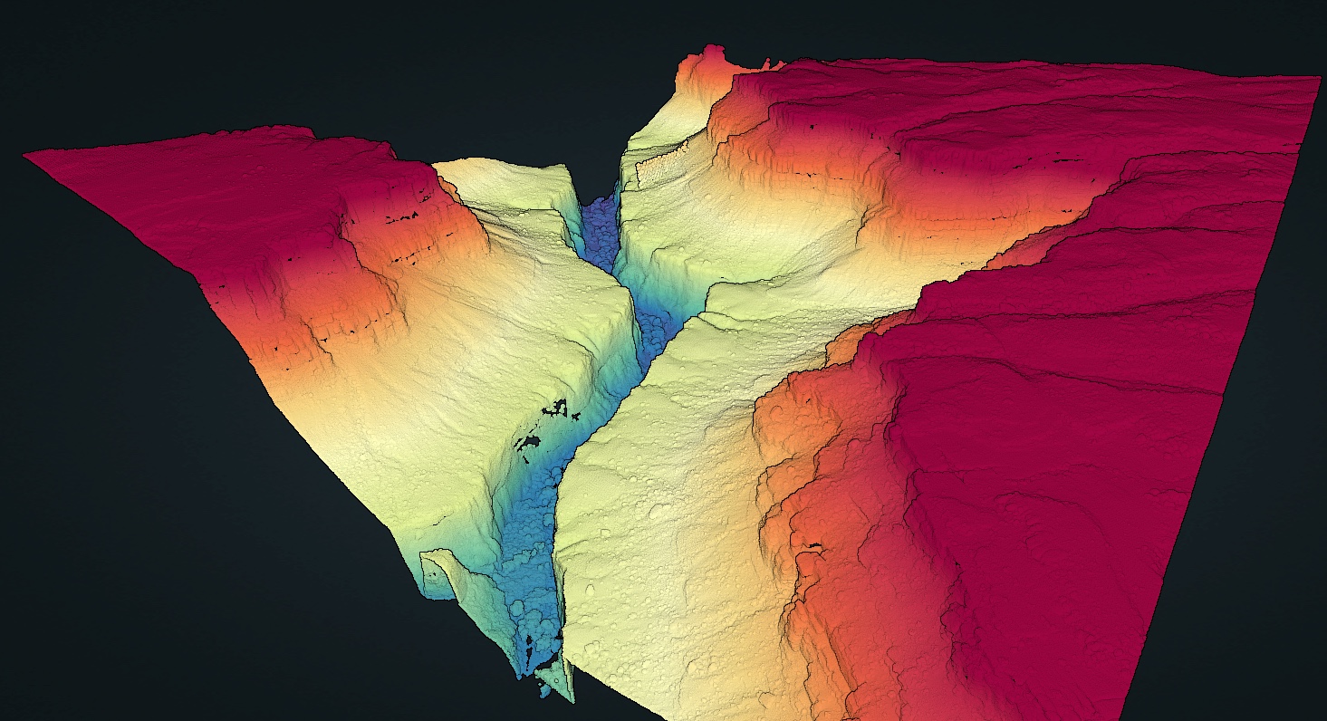
Colorized point cloud of the USGS 3DEP lidar data over a section of Havasu Canyon on the Havasupai Reservation. Data Source: USGS 3DEP Lidar: AZ MohaveCoconino 1 D23.
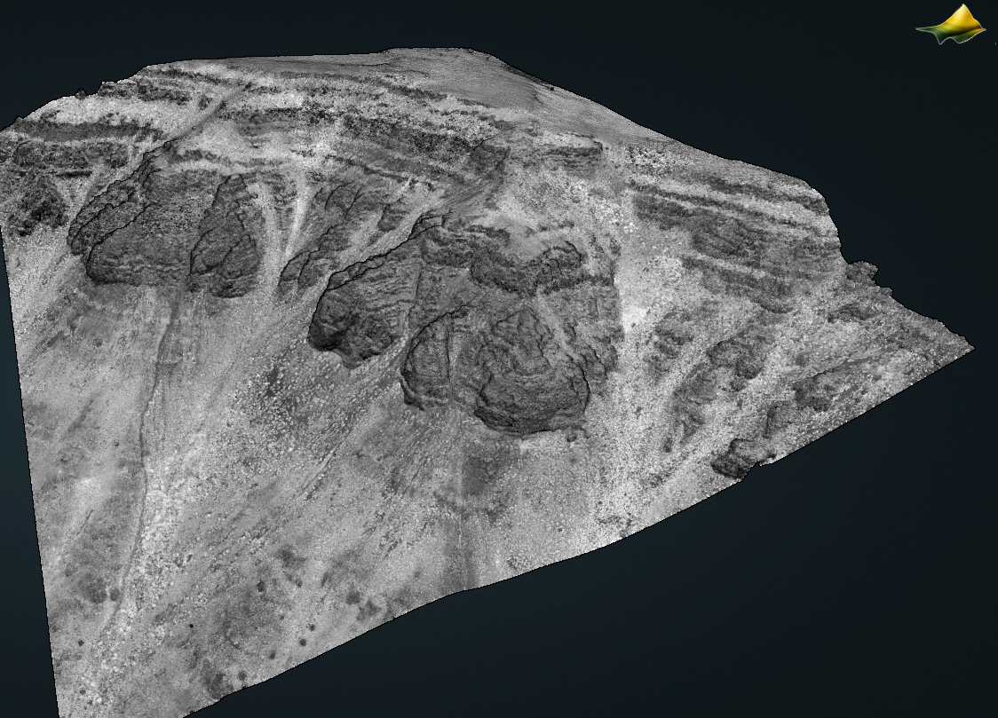
Point cloud colored by intensity of a section of Steens Mountain in Oregon. Data Source: USGS 3DEP Lidar: OR SouthEast 8 D22
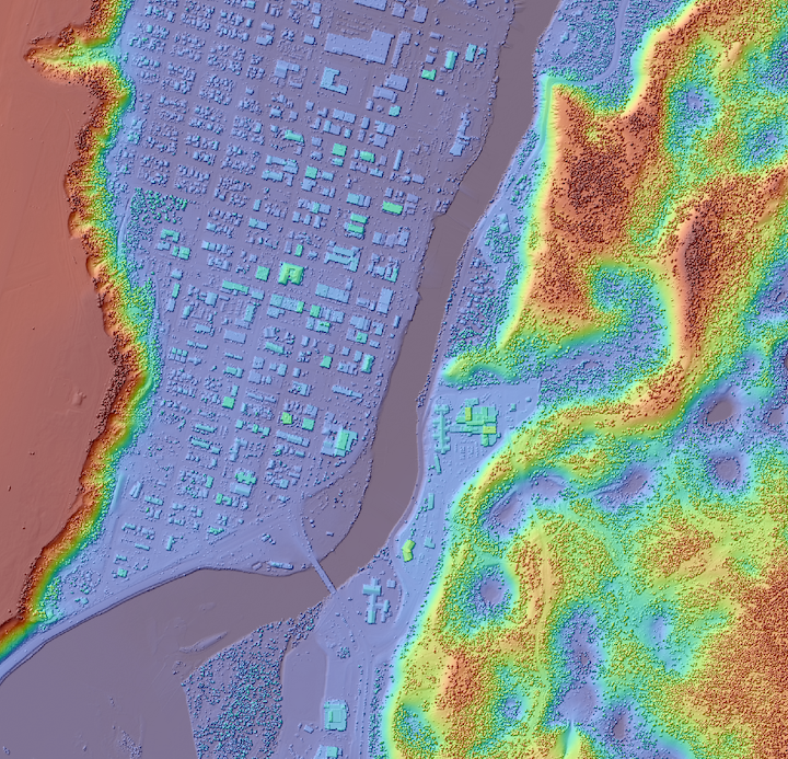
Digital Surface model draped on a hillshade of the Yukon River running through Whitehorse, Yukon, Canada. Data Source: NRCAN 1m DEM: High Resolution Digital Elevation Model Mosaic of Canada.
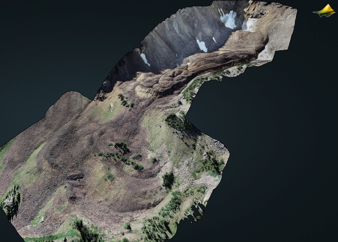
3D point cloud colored by RGB values of the Gad Valley Rock Glacier within Snowbird Ski Resort in Little Cottonwood Canyon, Salt Lake County, Utah. Data Source: CDS: 2023 Gad Valley Rock Glacier UAV Lidar Data.